Solidago altissima L. var. pluricephala M.C. Johnston
No images available.
Detail
- Family
- Asteraceae
- Botanical Name
- Solidago altissima L. var. pluricephala M.C. Johnston
- Common Name
- Synonym(s)
- Flora of Virginia Name/Status
- Solidago altissima L. var. pluricephala M.C. Johnston
- Comments
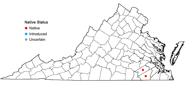
- A single specimen from Southampton Co. was received at VPI bearing this name as determined by Dr. John C. Semple in 2012. A second specimen, from Sussex Co., is cited in Phytoneuron 2022-16. A multivariate morphometric study by Semple et al. (Phytoneuron 2015-10, 1-31) identified this variant, which is reportedly common across the southeastern U.S., reaching its northern limits in southeastern Virginia. Compared to var. altissima, this taxon has an elongated, narrow inflorescence and reduced upper stem leaves, but intermediates are reported to occur over a broad zone of sympatry. The applicability of the diagnostic characters to Virginia material seems problematic, due to extensive morphological variation among populations of the species. Plants with reduced upper leaves and wide inflorescences, as well as plants with narrow inflorescences and unreduced upper leaves, can be found over much of the Coastal Plain and Piedmont. It may be that Virginia is in a zone where northern and southern variants of the species are insensibly intermingled over a sizeable area. Further study of this problem is needed.
- Habitat
- The Virginia applicability, distribution, and status of this variety in Virginia are uncertain. According to distribution maps produced by John Semple, it reaches its northeasternmost limits in the se. Virginia Coastal Plain; specimens are known from Sussex and Southampton counties, but the var. could very well be more widespread in that region. It presumably occupies similar open, often disturbed habitats as var. altissima but additional field and herbarium studies are needed to clarify this.
- Native Status
- Native
To save this map, right-click (control-click for Mac users) on the map and choose "Save Image As...".