Rudbeckia laciniata L. var. digitata (Mill.) Fiori


Detail
- Family
- Asteraceae
- Botanical Name
- Rudbeckia laciniata L. var. digitata (Mill.) Fiori
- Common Name
- Southeastern Cut-leaf Coneflower
- Synonym(s)
- Rudbeckia laciniata L. var. humilis A. Gray
- Flora of Virginia Name/Status
- Rudbeckia laciniata L. var digitata (Mill.) Fiori
- Comments
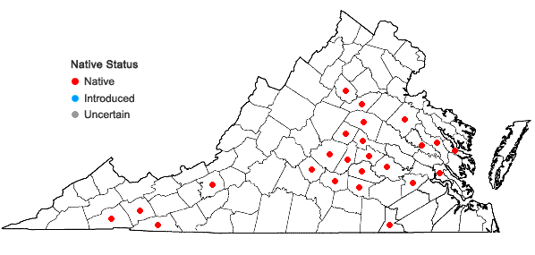
- The map is very incomplete, as most Virginia herbarium specimens are not identified to variety. It includes two vars. circumscribed by the Flora of the Southeastern States (FSUS, Weakley et al. 2023): the widespread southeastern var. digitalis and var. humilis of the Southern Appalachians, which is presumably restricted in Virginia to the sw. mountains. The concept of var. humilis varies between sources. According to Cronquist (1991), it is endemic to higher elevations of the Southern Appalachian mountains, reaching its northern limits in sw. Virginia. According to Urbatsch and Cox in FNA21, it is a more broadly distributed, southeastern taxon that subsumes plants described by Cronquist and FSUS. In Virginia, it has proven very difficult to distinguish these two vars. owing to extensive variability in vegetative characters (even within a single population), the clinal nature of differential characters, and the fragmentary condition of many herbarium specimens. In addition, the relationship is confounded by the fact that the holotype of Rudbeckia laciniata var. humilis was collected in Campbell County, Virginia (H.A. Curtis s.n. at GH), a location in the Piedmont, not the Southern Appalachians. An annotation on this specimen by Cox synonymizes it with R. laciniata var. digitata. The Curtis specimen is a good one, and does resemble plants that occur very widely at low elevations in Virginia. Further study to determine whether the Southern Appalachian populations are morphologically and genetically distinct is needed. At present, we are mapping this as part of var. digitata until these issues are resolved.
- Habitat
- Alluvial forests and swamps, seepage swamps, tidal swamps, riverbanks and bars, wet meadows, clearings, and roadsides; also in bogs, fens, seeps, and stream banks at higher elevations (var. humilis, if recognized). Flora of the Southeastern U.S. shows var. digitata (sensu stricto) as being restricted to the Coastal Plain, but it extends well inland in Virginia and is the prevalent var. in parts of the central and southern Piedmont. The disposition of infraspecific taxa in this species is unclear at present, and most Virginia specimens of Rudbeckia laciniata have not yet been determined to variety. Further study is needed (see Comments). Variety humilis (sensu stricto) occurs in the northern part of the southern Appalachians and is presumably restricted in Virginia to the sw. mountains; its status is uncertain.
- Native Status
- Native
To save this map, right-click (control-click for Mac users) on the map and choose "Save Image As...".